Features · The complete reference

Everything Road Voyage does, in detail.

Eight things no other RV planner ships together. Each built specifically for how RVers actually plan, drive, and adapt — not just translated from a generic road-trip app.

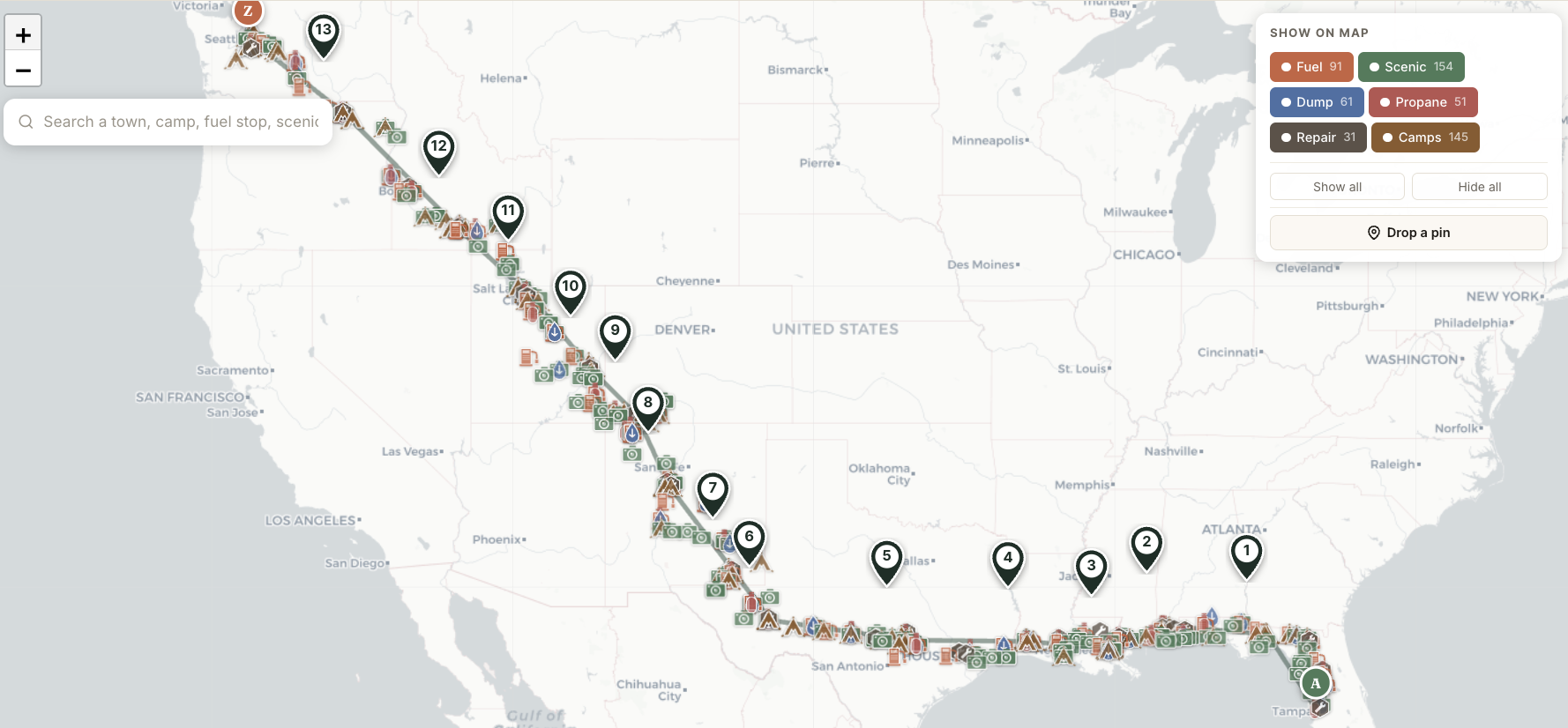
Full continental Tampa-to-Seattle route shown on a single map with all POIs along the way
The Tampa-to-Seattle demo trip — 14 Travel Days, 3,540 miles, hundreds of POIs along the route.
Jump to 01Travel Day 02Weather + elevation 03POI inventory 04Cascade edits 05Family sharing 06Print + offline 07Custom pins 08Search
01
The atomic unit

Travel Day organization — the unit of RV travel, finally treated like one.

Most apps treat a trip as a route with stops sprinkled on top. Road Voyage treats it as a chain of Travel Days — each with its own start, end, miles, hours, food preset, camp pick, weather, and grade warnings.
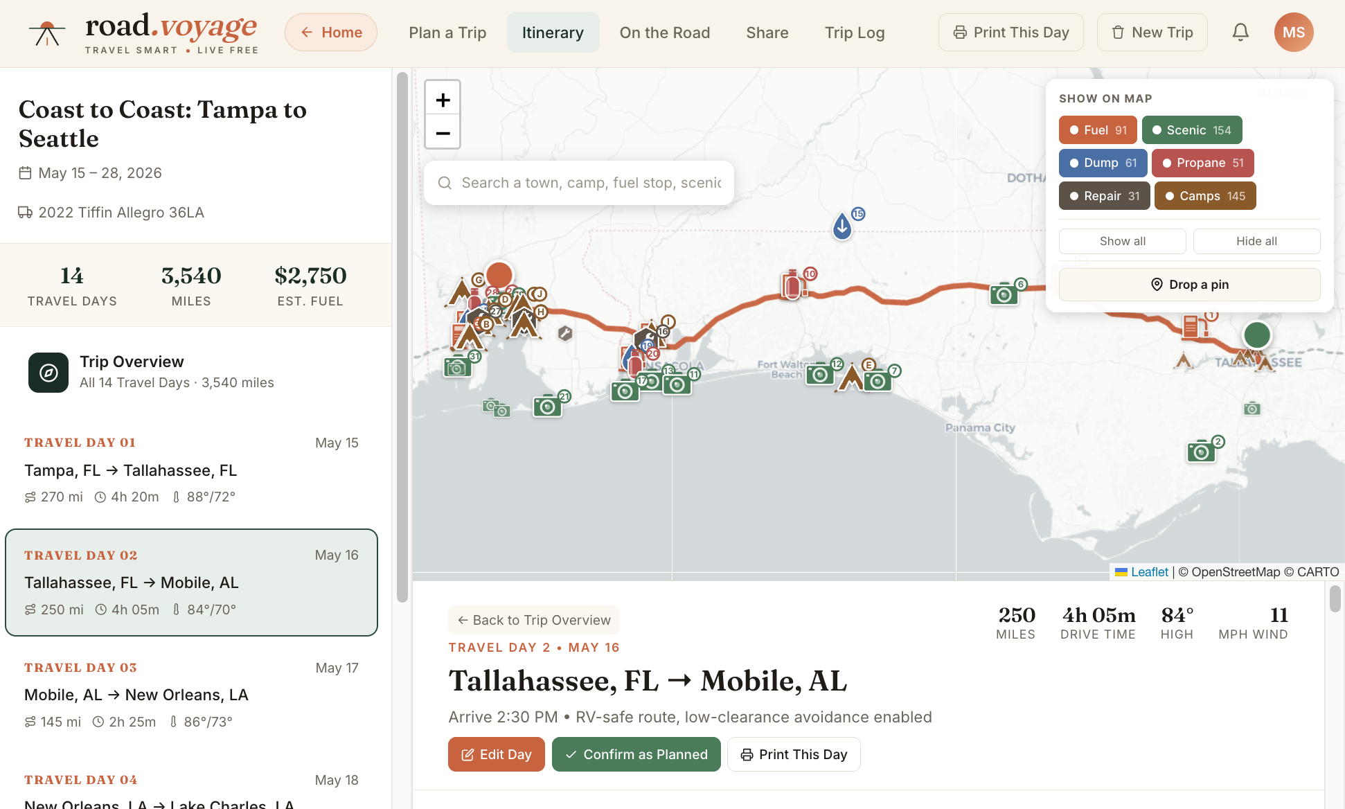
  • Each day is editable as a unit. Change one Travel Day's hours; subsequent days cascade automatically.
  • Status tracking per day. Planned · Confirmed · Modified · Pending — visual indicators across every surface.
  • Per-day budget. Fuel + camp + food preset + tolls + entries, computed from the day's actual numbers.
  • Per-day camp pick. Choose from 5–10 curated options with A/B/C/D selection that feeds back into day cost.
See a Travel Day in the demo trip
Travel Days directory and trip map showing the Tampa-to-Seattle Coast to Coast trip
02
Per-day driving conditions

Per-day weather + elevation — know what you're driving into before you turn the key.

Every Travel Day surfaces the day's high/low, conditions, wind, plus the elevation profile and grade summary. The boring stuff that decides whether the day goes smoothly or sideways.

  • Daily forecast at a glance. High, low, primary condition, and wind speed for each Travel Day. Pulled from NOAA + OpenWeather.
  • Severe weather alerts. Thunderstorms, high winds, winter advisories surface as inline alerts on the day's plan with timing recommendations.
  • Elevation profile per day. See the climb and descent before you commit. Min, max, total ascent, total descent.
  • Grade summary. "Mostly easy driving" through "Significant climbs" — automated based on the day's elevation curve. No surprise 7% grades on a tow day.
See weather + elevation on the demo
82° / 71°
Thunderstorms
18 mph wind
Afternoon Thunderstorms · Heavy rain and gusty winds expected after 2 PM along I-10. Consider an earlier departure.
Elevation & grade No notable grades · mostly easy driving
489 ft
Max
+486 ft
Climb
−10 ft
Descent
13 ft
Min
03
Multiple along every route

Comprehensive POI inventory — everything along the route, filterable.

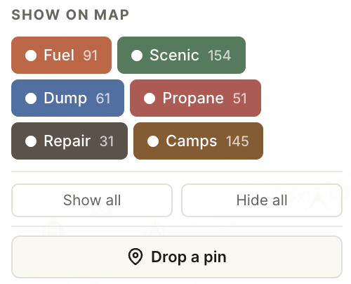
Six categories curated to your route: Fuel · Scenic · Dump · Propane · Repair · Camps. ~400 points of interest across the demo trip alone. Toggle filter chips to show or hide each category. Search across all of them to find a specific town, attraction, or stop.
  • Source-of-truth data per category. Recreation.gov for federal lands, Campendium for private RV parks, KOA + Harvest Hosts for member networks, GasBuddy for fuel pricing, AmeriGas + Suburban for propane.
  • Refreshed on appropriate cadences. Camps weekly, fuel daily, scenic stops quarterly.
  • Coordinate-anchored, not day-segregated. POIs along the entire route show up consistently — no jumping between different views.
  • Curation algorithm picks 5–10 per category per Travel Day from the broader pool. Right-sized for the day, not overwhelming.
See the POI map on the demo
Six POI category filter chips: Fuel, Scenic, Dump, Propane, Repair, Camps with counts for the demo trip
Six categories. Filter on or off. Tap any pin for details.
04
When reality changes

Real-time cascading edits — cascade what reality changed.

Day 6 added 47 miles? Day 7's start coord shifts east. Mileage recomputes. Dates ripple forward. The rest of the trip auto-corrects so you don't have to redo a spreadsheet on the road.

  • Geographic cascade. A day's end coordinate becomes the next day's start; the cascade interpolates camp positions along the new route.
  • Recursive day-split. When an edit pushes a day past your preferred max miles, the app proposes splitting into two days — recursively, across multiple impacted days.
  • Status lifecycle. Modified days flag as "pending" until you review; confirmed days lock in place.
  • All edits persist. localStorage in the prototype, Postgres in production — cascade state survives reloads and family-member edits.
See cascade in action
Before edit
Day 5
270 mi
Day 6
280 mi
Day 7
305 mi
Day 8
290 mi
Day 9
260 mi
Total · 1,405 mi · 5 days
Edit Day 6 → +47 mi
cascade triggers downstream days
After cascade · 4 days affected
Day 5
270 mi
Day 6 ↑
327 mi
Day 7 ↻
295 mi
Day 8 ↻
278 mi
Day 9 ↻
235 mi
Total · 1,405 mi unchanged — start coords + dates auto-rebalanced
05
Up to 5 members

Family sharing — one trip, the whole family.

On the Family plan, up to 5 members share full edit access to every trip. Co-drive, co-plan, or just keep everyone informed. On Pro, share trips publicly via slug-based read-only links for friends not on the plan.

  • Real-time edits — Server-Sent Events push changes as they happen. Your partner edits Day 8; you see it on your screen within seconds.
  • Last-write-wins (Phase 1) — Sequential editing handled gracefully; concurrent CRDT-style editing comes in Phase 2 if data shows it's needed.
  • Public share linksroad.voyage/t/atlantic-coast-2026. Read-only, indexed by Google, perfect for sharing with non-family.
  • Encrypted private share — On Pro, generate a tokenized URL with passphrase that bypasses public indexing.
Pricing for the Family plan
Atlantic Coast 2026
14 days · Tampa → Seattle · 3,247 mi
3 active
Family
SM
DM
JK
RM
+
4 of 5 seats
Sarah edited Day 6 mileage
just now
David confirmed Day 4 campground
2 min ago
Jordan added a custom stop
8 min ago
06
Works in dead zones

Print + offline — Idaho-Oregon border without panic.

Save the entire trip to PDF for the glovebox. Cover page + 14 day-by-day reference pages. Or use offline mode — the service worker caches your active trip and ~50MB of map tiles around the route.

  • Cover page — Trip summary, RV info, total budget, custom-stops list with SVG schematic snippets.
  • Per-day pages — Route directions with highway shields, weather + alerts, elevation profile, numbered stops, camp pick details, today's budget.
  • Offline read — All trip data cached in browser; map tiles cached in service worker. Idaho-Oregon border or Wyoming high plains: no degraded experience.
  • Edit queue — Edits made offline queue up and sync when reconnected. No data loss.
See a sample printed trip
07
Drop your own

Custom-pin drop — that Walmart you want to overnight at, the diner your sister-in-law swears by.

Click anywhere on the map to drop a custom stop. Name it, see nearby POIs, assign it as a Travel Day's start or destination — or just keep it as a floating reference. Custom stops persist, sync, and print.

  • One-click drop. Click map → name appears → dropdown to assign to a specific Travel Day.
  • Nearby-POI list. When you drop a pin, the 5 closest POIs from the inventory appear automatically — see what's actually around your new stop.
  • Assign as Travel Day endpoint. Move a Travel Day's start or destination to your custom pin via dropdown.
  • Persists in print. Custom stops with SVG schematic snippets show up on the cover page of your printed trip.
Try the drop-pin in the demo
+ + Sara's Diner Custom · 1.2 mi off route ASSIGN TO DAY 6 + +
4 custom stops · this Travel Day
Sara's Diner
Custom · 1.2 mi off route
Day 6
Walmart, Madisonville TX
Custom · overnight
Day 5
Famous BBQ — sister rec'd
Custom · 0.4 mi off route
Day 7

Watch the Tour or Try The Demo

This is a free demo of the RV trip planning tool we are building for the community. Before we take it too far, we want to share it with you and get your feedback. Please send your 2-cents to brad@road.voyage and register your email for newsletters and updates.